
Resources for city professionals

An Introduction to Environmental Insights Explorer
This guide is intended to provide city sustainability professionals with an overview of Environmental Insights Explorer, its insights, its data and collection methods, and common use cases for cities looking to meet their climate goals.
Get the latest, delivered.
Sign up to receive the latest news about Environmental Insights Explorer.

What is Environmental Insights Explorer (EIE) & how do cities use the platform?
Google's Environmental Insights Explorer (EIE) is built to empower cities globally with data and insights to help measure emission sources, run analyses, and identify strategies to reduce emissions — creating a foundation for effective action.

How Environmental Insights Explorer helps cities make data-driven climate decisions
Rebecca Moore, Director of Google Earth, Earth Engine & Outreach, introduces Google's Environmental Insights Explorer - featuring the City of Melbourne, Australia.

European cities use EIE for urban mobility planning
Learn how Environmental Insights Explorer (EIE) is being used by cities in Europe to inform regional transport emissions reduction plans & promote sustainable modes of travel

How to access, work with, download, and share city data in EIE
In this video, you'll learn how to access, work with, download, and share city transportation emissions, building emissions, and solar potential data in EIE.

Deep dive into the methodology and data of EIE
This video will give you a better understanding of the sources and methodology used by EIE for each type of environmental data we provide, including transportation emissions, building emissions, and rooftop solar potential.

How to measure, act, & track climate interventions with EIE
Learn how your city can use EIE to measure, act, and track their progress toward a sustainable future.

Guide to getting started with EIE's transportation data
Explore this guide created by Urban Transition Mission for cities looking to get started with the EIE platform for informing, actioning, and monitoring local mobility policies.

Technical Assessment of EIE Transportation Emissions Data
ICLEI Europe has undertaken a comprehensive analysis of EIE to better understand the extent to which it can assist European cities in advancing local climate action and achieving their carbon emissions reduction goals.

EIE Transport Assessment Overview for European Policymakers
ICLEI Europe and Google have been working together to better understand how EIE can support cities in bolstering local climate action and in achieving their local carbon reduction goals. The following is an Overview for European Policymakers.

How Google’s EIE is supporting Athens to assess their transportation emissions
This ICLEI Europe case study sets a founding example for cities on how to move from a top-down to a bottom-up transport emissions calculation approach, using Google‘s EIE data as a basis.

Data and insights from Google’s EIE support Greater Manchester 2040 Right Mix
This ICLEI Europe case study explores how Greater Manchester (GM) is using Google’s EIE data to inform the transport estimates used to track the progress of its Local Transport Plan, which defines the city‘s sustainable urban mobility strategy for the year 2040.

How Google's EIE supports Aarhus’s Green Transition
This ICLEI Europe case study explores how the city of Aarhus is using EIE's transportation emission data to assess emissions sources, conduct analyses, and formulate strategies for impactful actions.

How Google's EIE is supporting Izmir in the identification of low carbon mobility options
This ICLEI Europe case study explores how Izmir Metropolitan Municipality has used Google‘s EIE Transportation Emissions and Trips data to better understand their transport sector‘s carbon footprint and the mobility patterns of citizens.

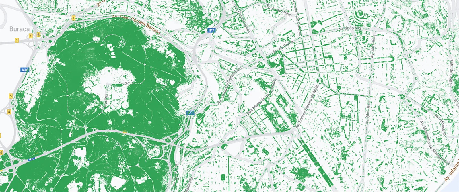
EIE's Tree Canopy data helps the City of Austin, Texas address extreme heat
Learn more about how Google Research is working to address climate change by using aerial imagery and AI paired with Environmental Insights Explorer data analysis capabilities.

Can AI help cool the world's hottest cities?
This Bloomberg feature explores Google's tree canopy & cool roofs technology for cooling our cities.

New Taipei City uses EIE to achieve its net-zero emissions goal
EIE is helping New Taipei City achieve its net-zero emissions goal by providing free Transportation and Building Emissions data to the municipality’s government. Learn how it has enabled their urban planners to research, plan, and implement carbon reduction strategies and track the impact over time.
How we're using AI to combat floods, wildfires, and extreme heat
We’re working to build more solutions — like our AI-based predictions and forecasting — that provide actionable information to help individuals stay safe and communities plan ahead.

ICLEI Guide to EIE for German Municipalities
This German language guide is intended for German municipalities interested in using data from Google's EIE tool, and illustrates how the platform can support planning processes for climate protection, particularly in the transport sector.

EIE’s Preview Insights: Data Available for Everyone
EIE's Preview Insights allows everyone to view a sample of environmental data for more than 40,000 cities and regions across the globe.
How we’re helping people and cities adapt to extreme heat
Heat alerts are coming to Search — plus more ways we’re helping cities and organizations adapt to rising temperatures.

How the City of Yokohama in Japan is leveraging EIE data
Learn how the city of Yokohama in Japan, is using EIE to raise awareness of global warming for the next generation to take action against climate change.
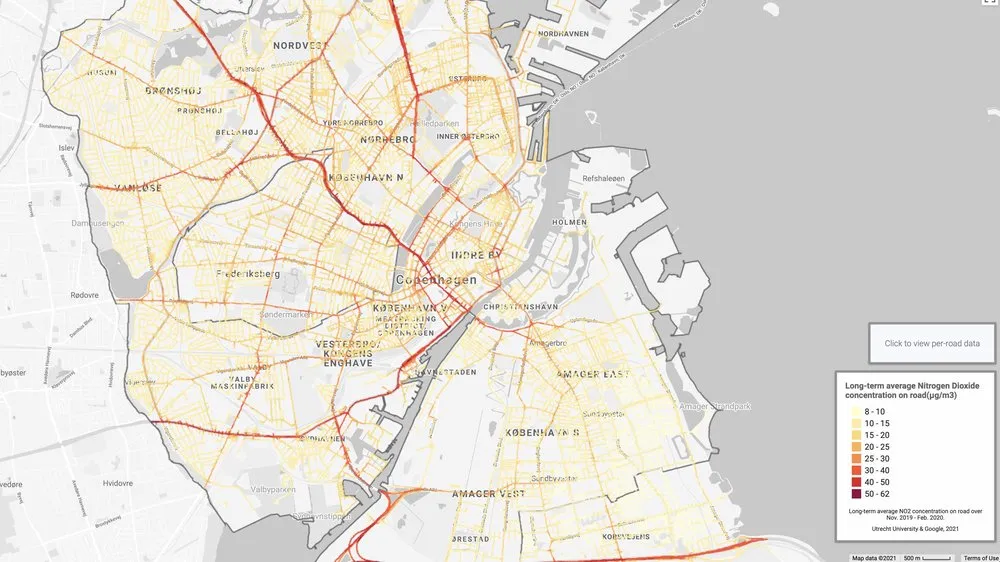
Lessons learned from the streets: How hyperlocal air quality data inform city actions
Copenhagen Solutions Lab partnered with Google and Utrecht University in The Netherlands on Project Air View using a specially-equipped Street View vehicle to measure street-by-street air quality.

How 5 cities plan to use Tree Canopy to fight climate change
Planting trees in cities helps provide shade, lower temperatures and contribute to cleaner air — all of which are huge benefits when it comes to adapting to the effects of climate change.

Street by street: How we're mapping air quality in Dublin
Learn how Dublin City Council is using EIE's Air Quality data to capture Dublin's air pollution street-by-street.

Los Angeles' City Forest Officer is shaping the city's tree stories
As Los Angeles first-ever City Forest Officer, Rachel’s work is shaping the tree stories that Angelenos will tell. Learn how Rachel and the City of Los Angeles used Google's Tree Canopy data understand current tree cover density,

Creating new tree shade with the power of AI and aerial imagery.
Extreme temperatures are becoming more common in cities where concrete and infrastructure are now creating heat islands. Trees are increasingly seen as a solution to both lowering street-level temperatures while improving quality of life.

How Kyoto City uses Environmental Insights Explorer
Kyoto City became the first Japanese city to be added to the EIE platform in October 2019. This Japanese language video explores how the city used the platform to act against climate change.

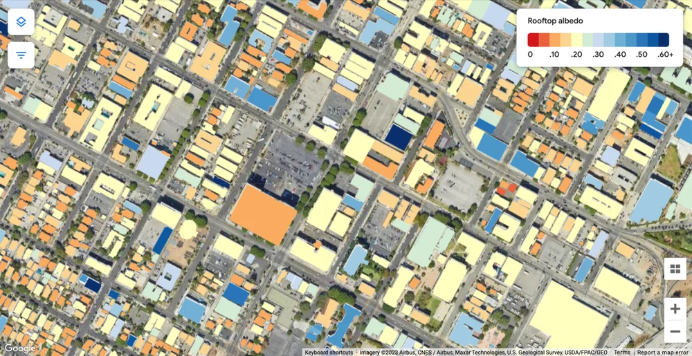
US cities put the power of emissions & solar data behind climate plans
Learn how US cities like Hartford, Connecticut and Lancaster, California have made use of EIE's solar and transport emissions data for climate action planning.

A breath of fresh air: Measuring air quality in Copenhagen
Learn how EIE's Air Quality data can help Copenhagen decrease air pollution.

An Introduction to Environmental Insights Explorer
This guide is intended to provide city sustainability professionals with an overview of Environmental Insights Explorer, its insights, its data and collection methods, and common use cases for cities looking to meet their climate goals.